Among the collections preserved at the Bronbeek Museum are a series of unassuming red file folders labelled:
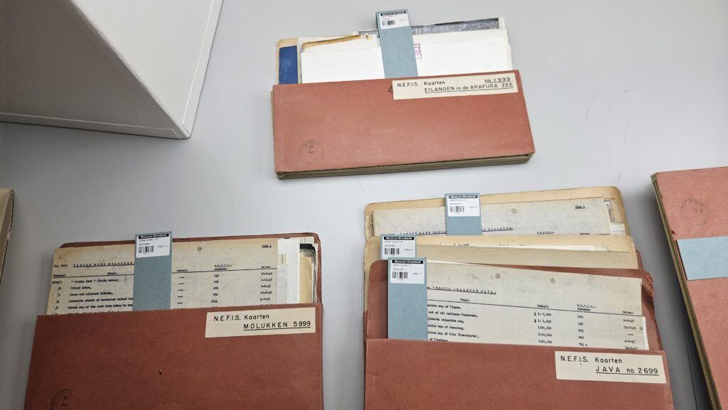
N.E.F.I.S. Kaarten – JAVA no. 2699
N.E.F.I.S. Kaarten – MOLUKKEN no. 5999
N.E.F.I.S. Kaarten – EILANDEN in de ARAFURA ZEE no. 1999
At first glance they appear to be ordinary filing folders. Yet they contain evidence of one of the most important and least visible aspects of the Allied war effort in the Southwest Pacific: intelligence gathering.
These folders belonged to the Netherlands Forces Intelligence Service (NEFIS), arguably one of the most significant Dutch military organisation operating from Australia during the Second World War. While Dutch military units, naval forces and air squadrons all made important contributions to the Allied cause, NEFIS occupied a unique position within the Allied command structure. Its intelligence was highly valued by both American and Australian commanders and played a significant role in planning operations throughout the Netherlands East Indies and Netherlands New Guinea.
Following the fall of the Netherlands East Indies in 1942, the Dutch lost direct control over the territory they hoped eventually to liberate. Yet military operations still required accurate information. Commanders needed to know the location of roads, harbours, airfields, fuel depots, beaches suitable for amphibious landings, and countless other details essential for military planning.
This became the task of NEFIS.
Operating from Australia, NEFIS collected, analysed and distributed intelligence relating to Japanese-occupied territory. The organisation worked closely with Allied intelligence services and developed an extensive network throughout the Southwest Pacific Area.
Importantly, NEFIS established its headquarters at Camp Columbia in Brisbane, which had become the centre of Dutch wartime operations in Australia. Camp Columbia also housed the Netherlands East Indies Government-in-Exile and several other Dutch military and civil organisations. Brisbane itself had become one of the principal Allied command centres in the Pacific under General Douglas MacArthur.
The proximity of NEFIS to American and Australian intelligence organisations was no coincidence. Intelligence cooperation was one of the defining features of the Allied war effort in the Southwest Pacific. Information moved constantly between Dutch, Australian and American agencies.
The surviving map folders at Bronbeek provide a glimpse into how this intelligence system functioned.
Inside the folders are typed indexes listing maps, scales, locations and reference numbers. They formed part of a carefully organised intelligence archive covering strategic regions throughout the Netherlands East Indies.
The Java collection focused on the political and administrative heart of the colony. The Moluccas files covered islands that had become important Japanese military strongholds. The Arafura Sea collection covered the waters and islands lying between northern Australia and Netherlands New Guinea, an area of immense strategic importance for reconnaissance, coastwatching, undercover NEFIS operations and future military campaigns.
The information contained within these collections rarely originated from a single source.
Australian coastwatchers operating on remote islands reported Japanese movements. Royal Australian Air Force aircraft conducted photographic reconnaissance missions. Australian naval units carried out hydrographic surveys. American forces supplied aerial photography and operational intelligence. Dutch personnel contributed their extensive knowledge of local geography, languages, administration and infrastructure.
NEFIS became the organisation responsible for integrating this information into a coherent intelligence picture.
The value of this work was recognised at the highest levels of Allied command. American planners frequently relied on Dutch intelligence concerning the Netherlands East Indies because Dutch officers possessed decades of accumulated knowledge about the geography, economy and administration of the archipelago. In many areas the Dutch remained the Allies’ most authoritative source of information.
The result was one of the most successful intelligence partnerships of the war. Intelligence produced by NEFIS supported Allied operations in New Guinea, the Netherlands East Indies and beyond. It helped identify strategic targets, evaluate Japanese capabilities and prepare for the eventual return of Allied forces into formerly occupied Dutch territory.
The map folders preserved at Bronbeek are therefore much more than archival material. They are surviving artefacts of a vast Allied intelligence network that stretched from the jungles of New Guinea and the islands of eastern Indonesia to the intelligence offices of Brisbane.
For Camp Columbia, they hold special significance. They remind us that the site was not only a military camp and the headquarters of the Netherlands East Indies Government-in-Exile. It was also one of the principal intelligence centres in the Pacific theatre.
The liberation of the Netherlands East Indies did not begin when troops landed on beaches. It began with gathering information, compiling maps, analysing reports and understanding the territory that lay ahead. Much of that work took place in Brisbane.
These modest folders are tangible evidence of that effort and of the important role Camp Columbia played in the Allied intelligence war.
We also know where the folders were produced lifting the veil on one of the many supply issues during the war.